How the amazing aviation innovations behind D-Day laid the foundations for modern air traffic control
4 June 2019On Friday 24 May 2019 more than 8,700 flights were handled in UK airspace in what is likely to be our busiest day of the year.
Highly specialised and experienced controllers, assistants, engineers, analysts, software developers and many other people, possessing more than 10,000 years of combined ATC experience, all worked together with sophisticated electronic aids in air traffic control operations rooms, control towers, remote radar sites, communications links and the wider aviation system to ensure this was a ‘normal’, if busy, day.
In contrast, on 6 June 1944, there were 14,674 flights handled with nothing more than flare guns and signal lamps, paper and pencils, blackboard and chalk, rudimentary radio navigation and an enormous amount of pre-planning, hard work, and determination driven by necessity.
Operation Overlord, the invasion of Normandy, arguably remains one of the most complex tasks ever devised. The statistics of those 24 hours are astounding: 160,000 troops (of which 24,000 landed by glider or parachute), 5,000 vessels and 11,000 individual aircraft took part.
While obviously bearing no relation to each other, today’s air traffic operation can trace some roots back to that day and to similar operations in preceding years.
By 1944, radar, used to great effect by the RAF in the Battle of Britain, had advanced in sophistication, as had an understanding of its application and countermeasures. In the early hours of 6 June, as the first pathfinder paratroops were jumping out over Normandy, heavy bombers of Nos. 617 and 218 Squadrons RAF were flying race-track patterns over the Channel near Calais and north of the Seine estuary, gradually creeping closer to the coast of France on every circuit. At precise intervals, the crew of each aircraft would throw bundles of aluminium foil strips now known as ‘chaff’ out of the aircraft. These strips, then called ‘Window’, were cut to the wavelength of German coastal radar stations, and would, given the aggregate movement towards France, resemble invasion fleets on their radar screens. This was an effort to sow confusion as to the actual target of the invasion, and perhaps to persuade the German High Command that any troops and fighting reported in Normandy would initially be dismissed as a diversion.

The plan for deception operations, including the Taxable and Glimmer ‘fake fleets’, and Mandrel jamming aircraft. Operation Titanic involved dropping half size mannequins behind enemy lines in northern France to create more confusion. Each ‘Rupert’, as they were called, included loudspeakers playing looped recordings of battle sounds, and firecrackers which would detonate randomly. Picture Credit: MoD, DEFE2/502
Radar’s susceptibility to interference was also exploited. At the same time, sixteen Short Stirling and four B-17 Flying Fortress bombers were airborne, forming a line from Portland in the west, to Brighton to the east. These aircraft were equipped with radar-jamming equipment called ‘Mandrel’, and drew an electronic veil over the real invasion fleet. None of the long-range German radar stations in Belgium and France could see through to pick up the tracks of the 1,200 transport aircraft ferrying parachute troops, or the 5,000 ships and landing craft, to Normandy. There were, however, carefully planned, intentional holes in this veil, in order to allow those same German radars to detect the ‘fake’ invasion fleet being created off Calais.
Many aircraft that night were using radio navigation systems. ‘Oboe’ was a forerunner of today’s SSR (secondary surveillance radar) where a ground station broadcast was then received by an onboard transponder which then transmitted a reply. The time difference between the broadcast and the reply being received allowed the aircraft position to be determined. The ‘Gee-H’ navigation system was also in use. This was the world’s first hyperbolic navigation system, where the aircraft would send a radio pulse and then measure the time difference between replying signals from various ground stations. The principles of ‘Gee’ were developed by the USA into LORAN for the war against Japan, becoming a navigation aid more suited to the vast distances over the Pacific Ocean. LORAN was then continually modified and served many users, including civil aviation well into the 21st Century.

An OBOE/9000 Ground Radar Station (Art.IWM ART LD 5780) image: a radar station with two metal frame mounted radars amidst a series of nissen huts surrounded by red brick walls. Copyright: © IWM.
Under the protection of the electronic countermeasures supplied by Mandrel, the first of the 1,200 transport aircraft and 150 gliders took off at 2256 on the 5 June. These were the six Handley-Page Halifax bombers towing Horsa gliders from Tarrant Rushton, undertaking Operation Deadstick. In these gliders were D Company , 2nd Battalion of the Oxfordshire and Buckinghamshire Light Infantry Regiment, who were to land next to, and seize, the bridges over the Caen canal and Orme river, on the eastern flank of the invasion area.
The routes these aircraft, and those that followed, were meticulously planned to ensure deconfliction from any other aircraft flying that night. Many of the leading aircraft made use of what was called ‘Eureka/Rebecca’. This was another form of secondary radar, where a radar pulse was received and then a reply was sent back. The ground station, named ‘Eureka’ after the Greek for ‘I have found it!’ would receive a pulse from the aircraft, and send a reply on a separate frequency. This was received by ‘Rebecca’, fitted in the aircraft, allowing the relative position of aircraft to the ‘Eureka’ beacon to be displayed (on a more pragmatic level, ‘Rebecca’ was so named through a contraction of the phrase ‘Recognition of Beacons’).
Ships fitted with ‘Eureka’ were moored in the middle of the Channel, providing guidance to allow the aircraft to follow their designated routes over the sea. The first soldiers to drop, known as pathfinders, carried their own ‘Eureka’ beacons which they would, upon landing, set up to guide the main force of transport aircraft to their drop zones. ‘Eureka’ was later developed into the Beacon Approach Beam System to permit aircraft to land in poor weather, a precursor to the Instrument Landing System we still use at airports today.

Other vessels performed other, vital roles. Three especially valuable ships sailed with the invasion fleet that night. Fighter Direction Tenders had been developed to detect enemy aircraft, and direct the Allied fighter response until land-based facilities could be set up. Displacing nearly 4000t and roughly comparable to the size of a contemporary Royal Navy Destroyer, they carried 180 RAF personnel, in addition to the Royal Navy crew of 100. They provided all elements of the system that could be found within the British air defence network, including the customary filter rooms and air control rooms known from many war films and newsreels. The current capability residing with the RAF’s No.1 Air Control Centre can trace its lineage in deployable air surveillance and control to these early pioneers.
At 0016, the first Horsa glider, piloted by Sgt. Jim Wallwork, touched down metres away from the Caen canal bridge. Just five minutes later, both bridges were in Allied hands and were successfully held until relieved by airborne reinforcements later that morning, and Commandos from the invasion beaches in the afternoon. These are now known as Pegasus Bridge and Horsa Bridge, named after the cap badge of the Parachute Regiment and the gliders that landed the troops.
Though the fighting was fierce, and many lost their lives, the efforts of those scientists, inventors, planners and military personnel enabled Operation Overlord to succeed, paving the way for the liberation of Western Europe.
The great pace of technological advancement during the Second World War took us into the electronic age, and as we reflect on the events of 75 years ago, and those lost on both sides, it is also worth remembering that many of those inventions, borne out of desperation and necessity, subsequently went on to transform how we travel and help make flying the safest way to travel.
You may also be interested in...

Machine learning, Artificial Intelligence and air traffic management
Read more
History of ATC terminology
Read moreComments
Please respect our commenting policy and guidelines when posting on this website.
04.06.2019
17:58
Susan
Reading this article by Adam has significantly increased my knowledge and appreciation of the sheer inventiveness plus the application of engineering design and logistic planning, which proved so vital in achieving maximum effect with minimum lives lost.
04.06.2019
19:51
Jim V
Jolly good article that highlights the courage, ingenuity and commitment of those brave warriors and scientists from the WW-2 era. Congratulations to NATS
04.06.2019
21:28
Simon Brown
Fabulous re-telling of a part of D-day I hadn’t known before! Well done Adam, a great read.
04.06.2019
21:48
Chris
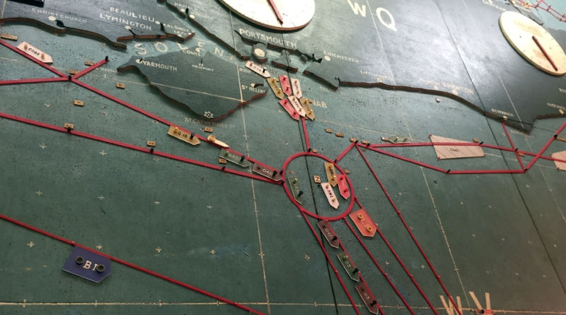
A few years ago I was the l was the ATC lead for Project La Manche and I was negotiating airspace changes with the French. I visited Reims ACC and whilst staying in Reims, I visited the Museum Of Surrender. Inside, they have the original maps which show the routes to the waypoints; ETRAT, VEULE and DIEPE which are still points used today and were the very subject of my conversations!
05.06.2019
07:19
Paul Field
Super article added to my knowledge of D-day. Recently read about the paratrooper who landed and was responsible for setting up the ground Eureka beacon – one wonders what would have happened if this did not work !
05.06.2019
11:59
Andy Knight
Fantastic article Adam, a really enjoyable read.
05.06.2019
13:45
Darren
Great article. I’d be interested to know how many flights not controlled by NATS happen on an average day to see if the UK ever gets near the D-Day total? There must be many uncontrolled GA flights each day.
05.06.2019
13:57
Rob Browning
Thanks for a fascinating article. Regarding your comments on BABS being a precursor to the modern ILS, during WW2 the US Army Air Corps used the SCS-51 system which is almost identical to the ILS with localiser, glidepath and markers. Several US bomber airfields in the UK were fitted with this equipment.
05.06.2019
17:00
Steve
I enjoyed reading this. Very apt.
05.06.2019
23:31
Jonathan Smith
A really fascinating read Adam
06.06.2019
08:25
Scott Rushing
Great article, really enjoyed it. I’m a USAF veteran who has worked with navigation equipment of all types. One thing, it’s not “the 5 June” (for example). It’s just “5 June” pronounced “five June”, with no “th” needed.
06.06.2019
08:30
David Wood
Fascinating article – especially interested to read about ‘Window’ radar countermeasures which my grandfather, Wing Commander Allen West helped develop ….
06.06.2019
08:37
David Harriman
Great article – A story to include when NATS next hosts a Royal institute of Navigation lecture.
06.06.2019
16:49
Geoff B
Excellent article! Very informative and well written!
06.06.2019
19:04
Nigel Spink
A great piece of work Adam!
07.06.2019
08:47
Pete R
Thanks for this Adam – I had little idea of this aspect of the operation before reading your article. Certainly adds to the history we have been seeing on the telly of late.
09.06.2019
03:37
Mr Baldo
Very interesting and informative article and a joy to read.
As a Brit, just one grammatical observation to stand up for our culture: “the 5 June” would flow better as “the 5th of June”.
10.06.2019
17:36
Chris Brobin
Great article – thanks for writing it.
21.06.2019
15:27
Peter Buckley
My D-Day Father witnessed much of the airborne armada over the Channel, from his landing craft on D-Day morning. I recommend a visit to the radar museum in Normandy to further understand the importance of the radar technology, and the tactics of deception used against the Nazi-radar on D-Day. It also adds to appreciation for Bentley Priory, and Bawdsey Radar and the significance of separating the radar from the control centre. The concrete bunker in Normandy was constructed as an impenetrable control post for people and the radar, and the D-Day troops were only able to besiege it and await surrender of the soldiers inside which took ten days. That historical fact creates a complete museum, with both the radar equipment and maps still intact on one site. Thanks Adam, I hope you wont mind me suggesting that you pass this along to the Radar Museum in Normandy which is run by volunteers, some of them ATCOs.
http://musee-radar.fr/web/le-musee.php
https://musee.memorial-pegasus.com/en/pegasus-bridge/
03.04.2020
20:41
Dave Paskell
Very interesting and readable account of the complexities of D-Day from the aerial point of view Adam. Thank you.