Europe 24 – an air traffic data visualisation
11 March 2014European airspace is some of the busiest and most complex anywhere in the world. Every day thousands of air traffic controllers guide millions of passengers safely to their destinations.
Yet to most people, the choreography going on above them is entirely unnoticed – it quite literally goes over their heads.
Some might say that is how it should be. ‘Why do I need to know about air traffic control as long as it gets me where I need to go?’ might be the argument.
But, that ignores one very important point. Airspace might be the invisible infrastructure, but it is every bit as important as the road, rail and utility networks we all rely on everyday. It is the lifeblood of our island economy, connecting the UK to the rest of the world.
Getting it right matters and we all have a stake in it.
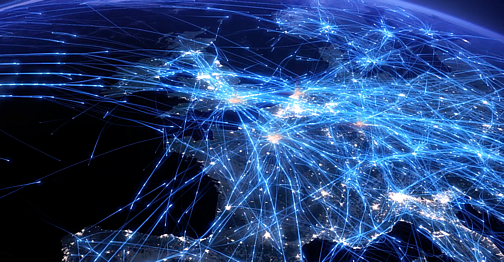
That’s why we created this data visualisation showing a typical summer’s day of air traffic from last year. It’s an amalgamation of two data sources – UK radar data from 21 June and European flight plan information from 28 July – and it clearly highlights the structure of airspace across the continent.
A few highlights include the North Atlantic tracks that connect Europe with North America, the airways that run up the spine of the UK, the holding stacks at London’s capacity stretched airports and the military manoeuvres off Anglesey in Wales.
We hope you enjoy it and that is acts as a small reminder of the incredible work air traffic controllers, working with pilots and ground crew, do every single day.
Vital statistics:
- On a typical July day there are around 30,000 flights across European airspace
- Approximately a quarter fly within UK controlled airspace
- The total distance flown by these aircraft is 25 million nautical miles
- That’s 998 times around the Earth
- Or 104 trips to the Moon
- On 21 June, 5,675 aircraft departed or arrived from UK airports, of which…
- 2,295 departed from or arrived at Gatwick (894) or Heathrow (1,401)
- 1,532 were overflights
- The video is 1440x faster than real time
You may also be interested in...
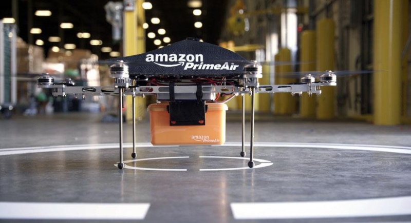
Amazon delivery drones – pie in the sky or a realistic future?
Read more
Airports beyond 2020 – future growth hinges on greater integration
Read moreComments
Please respect our commenting policy and guidelines when posting on this website.
11.03.2014
16:20
prlabpak
Why has no-one commented on this? This is a fascinating video showing how flight data has been analysed along with radar data to produce an amazing visual representation of the skies teeming with planes!
11.03.2014
20:18
Peter Copeland
It opens your eyes to the complexity that has developed in our skies over a hundred years.
12.03.2014
04:38
Colin Sweetman (@colsw)
Excellent visualisation. Well done.
12.03.2014
10:36
Paul Rogers
Fantastic, would be great as a screensaver too
12.03.2014
10:41
Paul Beauchamp
Senior Communications Manager, Brand PR & Marketing CommunicationsGlad everyone likes the video!
Paul – if you’re after some hi-res screen grabs, we’ve added some to our Flickr channel. They should make great desktop wallpaper. http://www.flickr.com/photos/natspressoffice/sets/72157642206189985/
Paul
10:41
Paul Beauchamp
Senior Communications Manager, Brand PR & Marketing Communications12.03.2014
13:54
Diego Rizzi
Really awesome! Great job!
12.03.2014
14:21
Justace
This looks great! Just like everybody else I am mesmerized and could simply watch this all day and not feel like I wasted any time. Can you tell me what tools you used and your workflow to create this masterpiece?
12.03.2014
17:16
aizolnai
Great work Paul, you’re a great communicator! This may not be the best forum, but can you share some of the geo-geekery behind the scenes? You know I did aerospace 25 yrs ago when ATC was basically mainframes…
12.03.2014
17:56
dreamer
music ?
12.03.2014
18:02
PhooeyToFear
Very cool. I’ll be doing a write-up about this as it should put some people’s fear of flying into perspective and help them overcome it.
12.03.2014
20:56
Fernando Marcos Maciel
Wow… this is really awesome. May I ask what kind of software/solution was used to render this? Tks!
12.03.2014
21:20
Maciej Dabrowski
It’s fantastic that it’s possible to show all of this in such a beautiful way. You did great job. Thanks
13.03.2014
12:10
Bryan
Absolutely amazing. Couldn’t you use this technology to help find that missing plane?
13.03.2014
14:22
Matthew Mills
Head of Digital CommsThanks for the comments. For info, the music is ‘Data day’ (apt eh!). It’s by Ben Ashford and available at focusmusic.com.
14:22
Matthew Mills
Head of Digital Comms13.03.2014
14:24
Dmitry
Do you think it would be possible to make a “screensaver version” of this video? (remove the time indication, loop seamlessly, beef up the resolution)
13.03.2014
20:01
Nick Wahoo
Awesome work. Everyone should be proud.
Sure I speak for many – any chance you could enlighten us with a brief on what you used to create…?
13.03.2014
21:07
Frank
Amazing, simply amazing. Also the music is great. Whats the name of the music title please?
14.03.2014
05:00
peter j. m
It is a showcase of how complex situations with a high risk component can be managed. Large and small companies could learn a lot from this.
14.03.2014
10:49
john
What is the cumulative effect of the planes exhaust fumes at this high altitude? Ever watch a contrail how it spreads across the sky. The real climate changer. Its blocking our sun. Giving more rain. Cloud seeding? Life blood or Death Blood? Wake up, smell coffee.
14.03.2014
11:15
PeterD
I love this video, thanks.
Is it just commercial flights or are private and military flights included in this?
14.03.2014
11:53
Paul Beauchamp
Senior Communications Manager, Brand PR & Marketing CommunicationsHi Peter,
Glad you like the video! We’ve been absolutely overwhelmed by the response. To answer your questions, there are some private aircraft included – you can see them especially clearly in the close up scene of Gatwick. In terms of military, keep an eye on the north west of Wales!
Thanks,
Paul
11:53
Paul Beauchamp
Senior Communications Manager, Brand PR & Marketing Communications14.03.2014
18:00
Brian Rickard
Very nice work!
One question. Since there are 1440 minutes in a 24-hour (solar) day, this video should be one minute long if it represents a 24-hour period at 1440X real time. Is it actually at 720X real time?
14.03.2014
18:50
Yeshwanth Venkatesh
Hello Paul, I really loved the visualization. I am a rookie data scientist, I was wondering if you can share the dataset that was used for this visualization ?
14.03.2014
21:21
Nadir Mattoo
Real time ALL planes in the air over the US….http://www.flightradar24.com/34.37,-100.15/4
15.03.2014
00:22
Doug
Awesome video!
15.03.2014
11:43
Pilotman
Impressive movie!
15.03.2014
14:55
Amanda
Fantastic video. Highly captivating and puts into perspective the operational side of the industry.
17.03.2014
16:56
Maria
This is an incredibly beautiful visualization! Just out of curiosity, how was it created? (What programming language did you use?)
18.03.2014
20:01
Horia
impressive, can you share some technical details about the data set and geographical rendering?
19.03.2014
23:43
Ivan Chao
Astonishing scene !
Could you make a film for Asia area ?
20.03.2014
17:14
Matthew Mills
Head of Digital CommsThanks so much for the feedback. We never thought so many people would find air traffic as beautiful as we do! In response to some of the questions, here’s some technical details…
Technology wise we are importing the radar and flight plan data into a custom written java program which re-formats the data into something the 3d software can handle.
The trails and backgrounds are rendered separately in Maya 3D and then the 20 or so layers generated from 3D are composited in After Effects to make one complete shot.
The individual shots are edited together, captioned and combined with music in ‘Final Cut X’ to give the finished result.
The speed is 1440 times normal speed across most shots although we slow the action down in the Heathrow and Gatwick shots. The time windows also overlap in places as we wanted to show certain scenes from different angles.
It took around 6 weeks in all to create from storyboarding our ideas to final product. We’re really pleased with the final result and hope it helps give others an insight to the 24x7x365 operation above our heads!
17:14
Matthew Mills
Head of Digital Comms24.03.2014
22:20
Dan Kashey
Anyone remember “Highways in the Sky”? CCF 1991
08.04.2014
09:29
Tao Nguyen
Hi Team NATS,
you have made an awesome video!
Would it be possible to license your visualisation for commercial use?
Greetings from Germany,
Tao
13.04.2014
01:11
Jesus Corujo Puga
Please use yours technology to find Malaysia Airlines flight MH370, in the night ocean are dark and this plane have several light
23.04.2014
18:51
Jürgen Sroka
Hi Paul great animation
I would like to use your animation for one personal multimedia art work, where a sort of UFO shows up in between all these others planes, i already made a first try and it looks great.
I could send you a sample ..
Would it be possible to get your permission for this?
best regards for your work anyway
Juergen from Germany
03.05.2014
03:59
Jerry Mathews
with all these data , just curious why MH370 disappeared and no one knows where it is
14.06.2014
19:05
David Fraser
Hi guys,
This is a tremendous animation. I enjoy debunking a certain theory involving contrails and I now use this video as an illustration of how busy our skies are.
many thanks.
10.09.2014
19:54
Alex
Excellent visualization. Are these visualizations public domain? Would they have to be licensed in any way to show?
17.11.2014
10:22
Davide CAVAZZINI
Paul, Matthew
First of all congratulation for the awsome video: it’s captivating from second 1 to the end.
It’ so good that I would like to use an extract to edit a small video for promoting my project for airline ticket website in the frame of a start-up context in France
Would it be possible to have your authorization?
Thank you
Davide
19.11.2014
03:29
ian guild
Not much of Europe until 1800
07.12.2014
20:18
Peter
Are you working on a simulation for the U.S.? Also, can you tell me how you average out the radar tracks for the London visualization? Your video is causing quite a stir among some of your American cousins. Outstanding work!
08.12.2014
14:10
Paul Beauchamp
Senior Communications Manager, Brand PR & Marketing CommunicationsThanks, Peter. That’s very kind of you to say. All our visualisations are created by a brilliant company called 422.South. I’m told that they pass all the position points for each aircraft into a NURBS curve (http://en.wikipedia.org/wiki/Non-uniform_rational_B-spline) and use that to draw a soft line revealing a history of where the aircraft has been. We don’t currently have plans for a US version, but you never know! Thanks, Paul
14:10
Paul Beauchamp
Senior Communications Manager, Brand PR & Marketing Communications11.05.2015
11:13
Clement Garrigue
Hi, your video looks really great; a symbol of constant move/dynamic innovation for the airline industry. I would love to use it in the background of my startup landing page – mentioning the credentials that you’d like me to display of course. Is that possible?
Thank you very much!
12.05.2015
10:16
Paul Beauchamp
Senior Communications Manager, Brand PR & Marketing CommunicationsHi Clement, thank you for you comment and I’m glad you like the video. You’re very welcome to use it providing you give an acknowledgement to NATS and include a link back to the blog post. Thanks, Paul
10:16
Paul Beauchamp
Senior Communications Manager, Brand PR & Marketing Communications27.05.2015
15:26
Ioan B.
Hi Paul! The video/audio impression is truly addicting. We’re currently redeveloping our website, and wondered whether you’d authorise us to use some 20 secs trim of the video & audio on our landing page intro. We serve clients internationally, and we would love to have it, as it is such appropriately suggestive. Should the audio be copyrighted to somebody else, I’d appreciate so much if you can let me know how can I get in touch. As you earlier indicated by you to Clement, we’d be more than happy to give an acknowledgement to NATS and include a link back to the blog post. Thank you very much!
14.06.2015
21:39
Mr R Border
I would very much like to know why some planes, turn right when they reach St ives in Cornwall, and of course their destination please. I live on the north coast of Cornwall and most days they fly down along the coast then head out over the Atlantic.
06.07.2015
12:17
Kdma
I wrote my BS thesis in computer science on the analysis of the global flight network, I can tell you that LHR is the most important airport in the world
29.09.2015
21:19
Peter Schmitt
Dear Paul,
I am wondering if it would be possible to use the picture on the top of this site as a cover image for a book? The book is a social science book about Europe, so the image would have rather a symbolic meaning about the interconnectedness within Europe. As it is a scientific book we are working on a very low budget…
I would be very grateful for a quick reply.
Thanks!
Best regards,
Peter
02.12.2015
14:20
Lori
Hi Paul, I really like the pictures and animation you did here. I wanted to know if its possible to use this photo for the background of a landing page of my startup company. Of course I will mention the credentials and link the picture back to this page.
01.01.2016
12:59
WelcomeToTheFuture
Looks like a cancerous growth to me – noise pollution and air pollution combined. Take away the pretty music and it is frightening what the Aviation Industry is doing to our skies.
09.04.2021
11:55
Mohammadreza Ilkhani
Hi Paul,
This is a really nice video.
I have a question about this video. I am a research fellow @ University of Nottingham and we are working on a research project about optimizing the civil aircraft structure. I am preparing an advertisement for our project that will be published by the University in Twitter and etc. I would like to use a video that show the huge demand of air traffic around EU and this video is so nice. I would like to know that is it possible to use this video from copyright point of view? Is it free to use for us? I don’t want to do some thing illegal’s.
Thanks