At the end of March, together with NAV CANADA, we started trial use of Aireon’s satellite based ADS-B system to track aircraft flying through the world’s busiest piece of oceanic airspace – the North Atlantic.
That has allowed us to progress from the traditional, procedural form of control where aircraft reported their position every 14 minutes, to one which is virtually real-time, with track updates every few seconds.
That transformation means we’ve been able to begin reducing aircraft separations and for airlines to begin flying at the speed that best suits them. That’s in addition to the clear safety benefit of having real-time surveillance and conformance monitoring (ie. knowing that an aircraft is complying with the clearance they’ve been issued), something we believe will significantly reduce the estimated risk of a collision.
It’s now been over two months since the service was introduced as part of a progressive trial implementation, and we’re getting a clear picture of what all that means in terms of early benefits to our customers

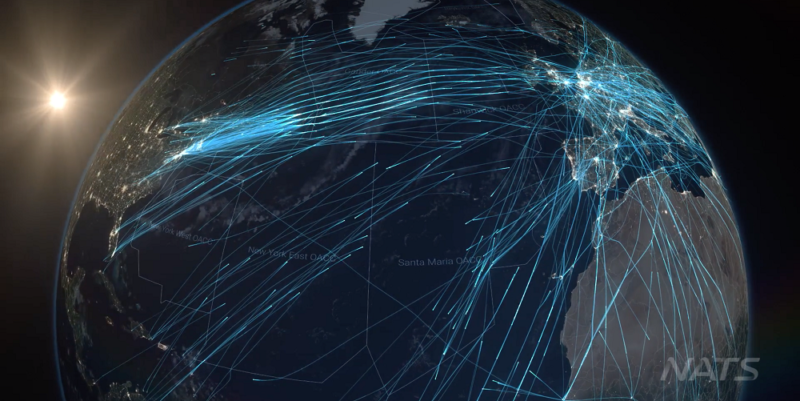
The North Atlantic is the world’s busiest oceanic airspace, with this image showing all the additional data we can now use thanks to the Aireon service.
The first thing to say is that our controllers love it. If I told the team that I was taking away their new tools and ADS-B surveillance tomorrow, I’d probably have a fight on my hands, such has been the positive impact upon the way they work and the quality of service they can now offer our airline customers.
In terms of the trial itself; of the 113 million ADS‐B reports received in April, all arrived within the target eight second update rate, with some as low as 3‐4 seconds. The average time it took for those position reports to reach a controller was just 0.17 seconds against a target of two seconds.
That’s truly incredible given the journey that data makes from the aircraft, through Aireon’s satellite network, then to its ground station before reaching our ATM system. But of course that’s only half the story. What’s more important is what that data is now allowing us to do.
Having high update rate, low latency, real-time surveillance means we have been able to safely reduce the distance between aircraft (14nm nose to tail, down from 40nm) and offer airlines that were previously assigned fixed speeds and heights the opportunity to take advantage of more flexible flight paths and optimum trajectories. That is reducing fuel use and greenhouse gas emissions, and helping them maintain their operating schedules.

Between 15 April and 27 May, around 12,000 flights flew their optimum speed for a total of 620,000 minutes. This is an important step as it puts flexibility and fuel efficiency back in the hands of the airlines, while also opening up the option to one day ‘stream’ aircraft into busy airports from further out in order to reduce the amount of stack holding on arrival.
What our reduced separation standards mean is that we’re seeing the beginning of the end of the Organised Track Structure (OTS). The OTS was introduced decades ago, itself designed to add additional oceanic capacity with a series of set routes designated each day, taking into account the location of the jet stream, to permit aircraft to efficiently cross the North Atlantic.
Being able to reduce separation standards and offer greater flexibility on routes, speeds and levels means 62% of traffic now doesn’t need to use the OTS at all, compared with 50% in 2015. That’s a trend we will now see accelerate as we continue to unlock all of the service improvements available to us through Aireon and our deployment of our new standards. Over the coming years, we estimate that 90% of airspace users will be assigned their requested trajectories, something that will support the progressive reduction and eventual removal of the OTS.

A thing of the past? A map showing a typical track structure.
The result will be safer, more environmentally friendly and fuel efficient operations.
We’re committed to extracting every benefit for our customers and are working hard to make that happen. The next project milestone will see us reducing the lateral separation minima from 23nm to 19nm and then to 15nm. That’s due this autumn and I look forward to keeping you updated on the progress of the trial.
Comments
Please respect our commenting policy and guidelines when posting on this website.
15.06.2019
11:29
Eddie Wallace
“Benefits for our customers “…this will always be measured financially. I just hope that all these substantial benefits are passed down to the fare paying public although I very much doubt it. Also the reliance on satellite based info is fine…..until the owner of the satellite starts to overcharge for the use of his” wee beastie”.