North Atlantic Skies – The gateway to Europe
26 June 2014Every day between two and three thousand aircraft fly across the North Atlantic, with the UK – and NATS – acting as the gateway to Europe.
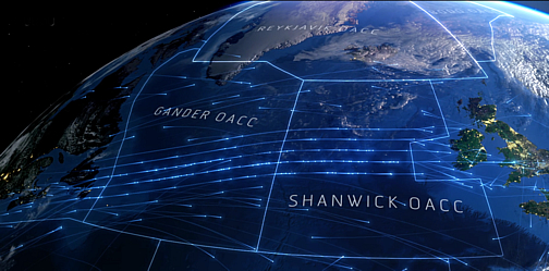
Up to 80% of all Oceanic traffic passes through the Shanwick Oceanic Control Area (OCA), which is airspace controlled by the United Kingdom. With this in mind, we created a data visualisation showing a day of traffic from August last year and the oceanic airspace structures that help to make it all work.
NATS controls the Shanwick OCA – made up of 700,000 square miles of sky – from our Prestwick Centre in Scotland. On a typical summer’s day we handle around 1,400 flights across the North East Atlantic, working to safely and efficiently shepherd them from the ocean to their final destinations, whether that’s in the UK, Northern or Southern Europe or further afield.

Our control centre at Prestwick from where the Shanwick airspace is controlled.
Controlling without radar
As you can see, the traffic is all fairly uniform, following very clearly defined routes. That’s because Oceanic airspace is unusual in that aircraft are not controlled using radar – radar is limited to about a 250 mile range – so we rely on pilots giving reports – either via satellite or High Frequency radio – at regular intervals and we use these reports to maintain separation between other aircraft.

In Oceanic airspace routings and reporting are based on latitude and longitude. Every ten degrees of latitude pilots make a report giving present position, height and the next two positions that they are intending to route. The controller can check that the flight is routeing in accordance with his clearance and amend or deal with any requests as required.
Traditionally, pilot reports were made using radio on High Frequency to operators in Shannon, Ireland. However developments over the past 10-15 years mean that now 80% of pilots can make these reports via satellite links from the cockpit direct to the controller. Controller–pilot data link communication systems enable the sending and receiving of text based messages, thus cutting out the requirement to make verbal reports.

Our controllers at the Prestwick Centre provide the service across Shanwick.
In radar airspace there is either 5 Nautical Mile (nm) or 3nm separation minima laterally between aircraft, however in Oceanic it is 60nm laterally and for aircraft following on the same route it is based on time – essentially 10 minutes apart. For aircraft crossing another aircraft at the same level it is increased further to 15 minutes. Therefore it’s vital we get accurate reports from pilots to ensure that separation is safely maintained at all times.
The North Atlantic Tracks
A major factor in the routeing of flights over the Ocean is the wind direction. There are huge jet streams over the Atlantic, predominantly flowing west to east at up to 150mph at between 30,000 feet and 40,000 feet.
Due to the amount of traffic flying at the same time and position of those jet streams, many flights want to fly at the same place at the same time. If we allowed all the flights to fly exactly where they wanted, we would actually reduce the capacity of the airspace because of the need to increase the separation between aircraft that cross each other.
Therefore we use a system to rationalise the traffic that sees them following one after the other, almost like roadways in the sky. This rationalisation is what we call the ‘tracks’ – something that you can see very clearly in the visualisation.

Our visualisation shows the track structure.
Every night, Airline Operators send their preferred routeing for all their flights to the Prestwick Centre based on winds, cost, airspace restrictions etc and we then take the area where most of the traffic wants to route and design a set of routes using latitudes and longitudes and label these from Alpha upwards.
The operators are then advised that night and if they wish to route within the area where the tracks have been designed for the following day they must follow the track structure. This system works well as it gives the airlines the opportunity to shape where the ‘tracks’ will be and also allows them to flight plan well in advance of the following day.

A map showing a typical track structure
How technology is changing
Due to the demand within the Ocean and the fact that it can be quite restrictive due to the large separation requirements it is an area that is constantly evolving and looking for improvement.
On many occasions Oceanic airspace is at the cutting edge of new technology or big changes of procedures. For example, changing separation from 2000 feet to 1000 feet was first brought in on the Atlantic before being introduced some time later round the rest of the world.
Oceanic airspace is also the first to be using satellite technology for communication and controlling purposes, with Automatic Dependent Surveillance-Broadcast (ADS-B) and Automatic Dependent Surveillance-Contract (ADS-C) tests being trialled some time ago and now being used on a daily basis.

Inside the Operations room at our Prestwick Centre
All of the changes in technology will deliver a much greater degree of predictability which means the aircraft will be able to fly more optimal routes carrying less fuel and therefore operating more efficiently.
Facts and stats
The Shanwick OCA is the busiest of all North Atlantic Airspace regions. It is often referred to as ‘the gateway to Europe’ and around 80% of all North Atlantic Air Traffic passes through it, demonstrating the strategic importance of our Prestwick Centre and UK airspace.
The visualisation shows Transatlantic traffic over a 24 hour period taken from a day in August last year and includes 2,524 flights, of which 1,273 pass through the Shanwick OCA. At our busiest periods in the Summer, traffic can peak at 1,500 flights a day passing through the Shanwick OCA.
Comments
Please respect our commenting policy and guidelines when posting on this website.


26.06.2014
13:55
Kieran O'Carroll
Thanks for the nice article and video Alastair. Nice work on the NAT. Slainte!
26.06.2014
15:04
Darragh Owens
Very interesting article… although surely the OCA is bigger than 3000 square miles!
26.06.2014
22:41
Finlay Smith, Ops Supervisor, Prestwick Centre.
Darragh. You’re quite correct. The Shanwick OCA covers an area of around 700,000 square miles. It’s not the biggest OCA in the world but it is the busiest! Thanks for pointing our our miscalculation.
27.06.2014
10:38
Campbell Airlie
Nice visualisation. Impressed with your office, although have you noticed the big plane in the background that might be off course! You say that 80% of North Atlantic flights go through your OCA but the numbers of flights quoted suggest nearer 50%. I think.
27.06.2014
14:07
Grant Wilson
Hi,Ibelieve that there is a typo in the opening sentence:
Up to 80% of all Oceanic traffic passes through the Swanwick Oceanic Control Area (OCA), which is airspace controlled by the UK airspace.
Expect that should read Shanwick.
Brgds, LGW
27.06.2014
14:50
Matthew Mills
Head of Digital CommsApologies Grant – you’re absolutely correct – we’ve now changed it. Thank you!
14:50
Matthew Mills
Head of Digital Comms27.06.2014
22:53
Andrew MacBride
Gorgeous visualization; who did the music?
28.06.2014
00:33
John Nash
Is it not every 10 degrees of longitude, not latitude that they report.
28.06.2014
01:37
Joe Chambers
Findlay glad to know u are still working
28.06.2014
10:18
Mauro Danieletti
I like it! Truly mesmerizing video but should we read the time as UTC, UK time or something else?
By the way great post, it really gives a cue of the effort that’s going on… above our head.
28.06.2014
12:21
Nicky Mason
Nice work by Mr Brunton
28.06.2014
20:50
Matthew Mills
Head of Digital CommsThanks for the comments. The time is UTC and the music is Nebula by Cyrus Shahrad. You can find it here: bibliothequemusic.com/albums/cinematic-beats/
20:50
Matthew Mills
Head of Digital Comms02.07.2014
11:21
Matthew Mills
Head of Digital CommsFor information, Alastair asked me to put this post in Jim’s name – as he did most of the work on it while Alastair was away on business.
11:21
Matthew Mills
Head of Digital Comms03.07.2014
13:49
Kevin
Great visualizations. Is there a possibility of getting home High res stills. Would love to have a set for my Mac’s spaces.
03.07.2014
17:02
Eamonn Riley
The video has made the Guardian web site front page under Top Videos.
03.07.2014
17:05
Eamonn Riley
Note that ADS-C has been used for some time. ADS-C and CPDLC have enabled a reduction in longitudinal standards down from 10 minutes to 5 minutes. The NAT has a goal of removing tracks and allowing free routeing by 2025.
03.07.2014
17:23
Matthew Mills
Head of Digital Comms@Kevin – you can download some stills from our Flickr page https://www.flickr.com/photos/natspressoffice
17:23
Matthew Mills
Head of Digital Comms03.07.2014
22:16
Adam Chaney (@adam_chaney)
That is amazing that that takes place everyday.
08.07.2014
22:18
John King
What software did you guys use to render this visual? It is beautiful!
09.07.2014
06:47
Matthew Mills
Head of Digital CommsHi John. The trails and backgrounds are rendered separately in Maya 3D and then the 20 or so layers generated from 3D are composited in After Effects to make one complete shot.
The individual shots are edited together, captioned and combined with music in ‘Final Cut X’ to give the finished result.
06:47
Matthew Mills
Head of Digital Comms18.11.2014
21:05
redlandrider
Brilliant explanation of a complex topic, cut down into relatively simple pieces. Is it semicircular rule over the Atlantic – even numbered flight levels out, odd numbers heading back to Britain?
22.11.2014
23:31
Stephen McClure
Nice overview and great video Jim, although its a shame you couldn’t find a photo of one of our Oceanic controllers to use and made do instead with a radar sector.
24.05.2015
20:51
nitronoddyuk
Fantastic visualization of the NATS. Being a flight sim pilot looking to stretch my wings from EGHH to Canada / USA it’s great to learn the correct paths to take.
29.05.2015
11:31
Peter Magill
Can you please describe the planned changes to NA MNPS track spacing?
09.11.2015
15:19
Nick Lynch
I’m hearing their are some major changes to the Nat Track system this week on Nov 12, 2015. Could you please provide us with some details on the changes. Thank you.
11.11.2015
16:39
Paul Beauchamp
Senior Communications Manager, Brand PR & Marketing CommunicationsHi Nick – thanks for your question. We are working on a project to make changes to the NAT Track system to increase oceanic capacity, but it won’t be tomorrow. Rest assured we’ll release more details at the time. Paul
16:39
Paul Beauchamp
Senior Communications Manager, Brand PR & Marketing Communications12.02.2016
10:39
Julie Hoad
For flights that are travelling between the US and mainland Europe, why are they routed across the UK landmass when neither their departure or arrival is in the UK? Why not over the Channel or North Sea?
24.02.2016
11:56
Paul Beauchamp
Senior Communications Manager, Brand PR & Marketing CommunicationsHi Julie, I know it seems a little strange, but because the Earth is spherical, routing over the UK is often actually the shortest and quickest route, especially when you take into account the North Atlantic Jet Steam. FlightRadar 24 has a good description of the concept on their blog: http://www.flightradar24.com/blog/flight-paths-and-great-circles-or-why-you-flew-over-greenland. I hope that helps explain it.
11:56
Paul Beauchamp
Senior Communications Manager, Brand PR & Marketing Communications14.07.2016
19:11
Frank Ketcham
How can I find the growth in the number flights operated in NATs over the last 20 years
17.09.2019
12:04
Allan horne
A very responsible and busy job I take my hat of to all controllers and supervisors well done to you all
22.06.2020
04:04
Charles Sharkey
I really enjoyed watching the video, Jim. Also, I love the music.. Thanks for this.