
Part 1: What are Functional Airspace Blocks?
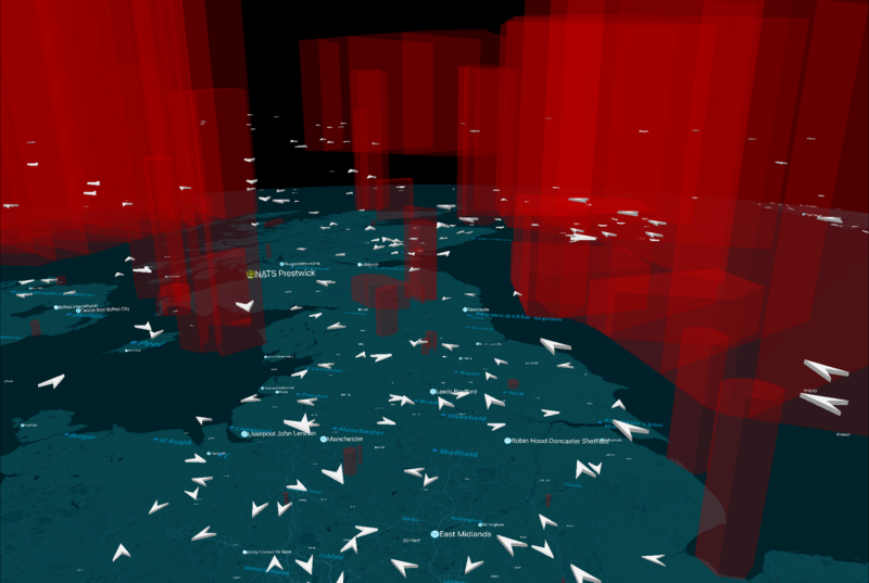
Last week we launched Airspace Explorer, our beta app that uses real radar data to track aircraft in the UK.
We’ve been overwhelmed by the positive response and delighted to see so many people enjoying playing with it and exploring the skies. One of the things we want to achieve was to highlight the importance and structure of our airspace – the invisible and hidden road network in the sky in which our controllers manage flows of air traffic.
Honestly, this app is probably the most impressive creation I’ve seen recently. I’m not exaggerating either! Top work @NATS https://t.co/cqbInIIvyY
— Ben (@benwhitworth1) April 11, 2017
Over the course of the next few weeks, I want to explore how our airspace is made up and how you can use the app to explore it. It’s also worth pointing out that much of the airspace you can see in Airspace Explorer is based on designs drawn up from the 1960s and 70s for the likes of VC10s and B727s, and I can guarantee you won’t find many of them flying today. It’s why our airspace is in great need or redesigning and modernisation.
At it’s highest level, all airspace around the world is divided into Flight Information Regions (FIRs). Each FIR is managed by a controlling authority that has responsibility for ensuring that air traffic services are provided to the aircraft flying within it. The CAA is the controlling authority for the UK and NATS provides air traffic services for them.

FIRs vary in size. Smaller countries may have one FIR in the airspace above them and larger countries may have several. Airspace over the ocean is typically divided into two or more FIRs and delegated to controlling authorities within countries that border it.
In some cases, FIRs are split vertically into lower and upper sections. The lower section remains referred to as a FIR, but the upper portion is referred to as an Upper Information Region (or ‘UIR’).
Still with me? Well, the airspace within a FIR (and UIR) is usually divided into pieces that vary in function, size and classification. Classifications determine the rules for flying within a piece of airspace and whether it is ‘controlled’ or ‘uncontrolled’. Aircraft flying in controlled airspace must follow instructions from air traffic control. Aircraft flying in uncontrolled airspace are not mandated to take air traffic control services but can call on them if and when required (e.g. flight information, alerting and distress services).

UK Airspace is divided into three FIRs; London, Scottish and Shanwick Oceanic. The London FIR covers England and Wales. The Scottish FIR covers Scotland and Northern Ireland. The Shanwick Oceanic FIR covers a region of airspace totalling 700,000 square miles over the North East Atlantic.
NATS manages the airspace within these FIRs from our two control centres – one in Swanwick, Hampshire and the other in Prestwick, Ayrshire, and we’ll talk about the different operations within those centres next week.
In the meantime, if you’ve got any questions about the app, or airspace leave a comment and we’ll do our best to find an answer for you. Or take a look at our FAQs to see if we’ve already covered it.
And don’t forget, if you haven’t already downloaded it, Airspace Explorer is available now from the App Store.
You may also be interested in...

Will a circular runway ever be cleared for take-off?
Read moreComments
Please respect our commenting policy and guidelines when posting on this website.
20.04.2017
01:47
Daniel Dziminski
when will the android app be released?
25.04.2017
17:12
I Miles
android please
10.05.2017
13:28
Phil
yeah an android version would be nice
11.05.2017
07:45
Matthew Mills
Head of Digital CommsHi folks – I’m afraid the app is only currently available on iPad. This is because it evolved from an internal app we use at NATS – which was standardised on iPad. However we’ll certainly consider porting to Android and other platforms if the app proves popular.
07:45
Matthew Mills
Head of Digital Comms15.05.2017
13:16
Mark McGillivray
Would there also be any chance of a web-based version of the app for Windows? (for those of us who dont have a tablet!) Thanks.