

North Atlantic Aireon trials: six months in
3 October 2019It’s now been six months since NATS and NAV CANADA introduced Aireon’s space-based ADS-B service over the world’s busiest oceanic airspace, the North Atlantic.
For those that might not have been following developments, at the end of March we started a trial introduction of satellite-based ADS-B surveillance to manage air traffic over the North Atlantic, where we serve over 500,00 flights a year.
Up until that point, we had been working with a satellite-based messaging system that delivered aircraft position reports every 14 minutes, something that’s long been the standard way of handling air traffic outside of terrestrial radar coverage. However, with that technology came limits on how close we could safely clear aircraft trajectories, and therefore how many aircraft could safely access the most fuel-efficient routes and levels.
In comparison, Aireon’s new ADS-B service provides aircraft position updates every few seconds and is continuing to prove itself totally transformative in terms of the service we are able to deliver to our customers. We’ve been able to reduce our minimum safe separation between flights from around 40nm to as low at 14nm (nose to tail), freeing up more space on those more fuel and environmentally efficient routes and levels.
From 28 March to the 31 August over 4,400 more flights were assigned their requested level when compared to the same period in 2018, most of which were previously flying 2,000 or 3,000 feet lower than requested, our trial performance is already indicating noteworthy fuel burn and environmental improvements.

The North Atlantic is the world’s busiest oceanic airspace, with this image showing all the additional data we can now use thanks to the Aireon service.
Over that same period, we were also able assign 3,419 more flights their assigned route, while around 43,000 flights – over one third of all eastbound traffic – were instructed to “Resume Normal Speed” for a total duration of 2.2 million minutes, or 37,000 flight hours. Flying at “normal” speed allows flight crews to fly at the speed that best suits them, enabling flexibility to speed up, slow down to meet their schedules, or simply to fly at the most economical speed instead of the totally fixed speed we’ve had to operate for decades.
These improvements don’t just translate into better fuel and environmental performance, they also provide a corresponding safety benefit. By reducing the number of flights where we’ve changed their level or route, we’re simultaneously reducing the safety risk of level busts (where an aircraft climbs or descends to a different level than assigned by ATC) and of Navigational Errors (where an aircraft may navigate to the wrong location or coordinate), both of which can happen when flight crews inadvertently follow their planned trajectory (their flight plan) and not the conflict free trajectory assigned in their ATC Clearance.
The changes we’ve made to our ATM system have received a warm welcome from our controllers, whilst our new Aireon service has delivered 134 million ADS‐B reports since the end of March, all of which arrived within the target update rate of eight seconds, with most as low as 2-3 seconds. The average time taken for these reports to reach a controller was just 0.19 seconds, well within our target of two seconds or less.
So its been a good start to this new way of controlling, but there’s more to come…
Later this month, we’ll extend our trial by safely reducing lateral separation minima, dropping initially from 23 nautical miles (wingtip to wingtip) down to 19, with a further reduction to 15 nautical miles expected from 2020, providing us with greater flexibility and flight efficiency for traffic on certain complex routings.

From the end of January 2020, non-datalink equipped aircraft are not permitted to fly in Oceanic airspace. NATS has led the negotiation of an exemption in the “South East corner” of the oceanic airspace we control. This airspace is very complex, integrating over 100,000 flights each year operating North/South between the UK, Ireland and Scandinavia to Spain, Portugal and the Canary Islands with East/West flights between Europe, North America and the Caribbean.
We will be using Aireon data to enable non-equipped aircraft to continue to use this airspace, with the introduction of Very High Frequency (VHF) communications, and two new dedicated tracks created to support this traffic. The (VHF) radio communications being delivered by our oceanic partners at the Irish Aviation Authority in the airspace around the Bay of Biscay for the first time.
This has been a key priority for our customers and ICAO and this step, ahead of the Datalink equipage deadline set for January 2020, represents a crucial delivery of our commitment to assuring the long-term availability of this important part of Europe’s route network.
The North Atlantic is the busiest piece of oceanic airspace anywhere in the world, acting as Europe and North America’s transatlantic gateway. What we’ve developed here is important not just for the airlines that use it, but for the wider industry worldwide with our deployment of new standards and transformational new technology yielding safety, capacity and environmental performance improvements that we’re sharing with others.
This is a hugely exciting time and I’ll be back with a further update towards the end of the year.
You may also be interested in...
Getting ready for a space-based revolution
Read more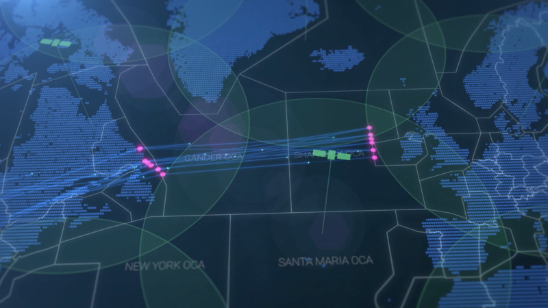
NATS and NAV CANADA share joint vision at IATA Ops Conference
Read moreComments
Please respect our commenting policy and guidelines when posting on this website.